Recent advancements in 3D mapping technology are providing a fresh impetus to the realm of autonomous navigation. A noteworthy contribution in this domain originates from AIT researchers Philipp Glira, Christoph Weidinger, and Clemens Hofbauer, who were acknowledged as authors of one of the best conference papers at the IEEE International Radar Conference 2023 in Sydney. Their paper, titled "Robust 3D Mobile Mapping with Radar Sensors: A Real-Time Approach for Autonomous Navigation," introduces an innovative methodology for generating elevation maps from 3D radar point clouds tailored for autonomous vehicles, work machines, and other robotic systems. Demonstrating the feasibility of a coarse 3D reconstruction of the environment using radar sensor technology on mobile platforms, their findings will significantly contribute to enhancing the efficiency and dependability of autonomous navigation systems.
Robust 3D Mapping in Challenging Environments and Bad Weather Conditions
Traditionally, stereo cameras and lidar sensors have been used for dense environmental reconstruction in autonomous systems. These sensors provide accurate information about the environment, but only under favorable weather conditions. This means that in poor visibility conditions, the systems are severely limited in their functionality. In contrast, radar sensors operate at wavelengths that significantly mitigate the effects of poor visibility. They are therefore a promising and robust alternative to lidar sensors and cameras.
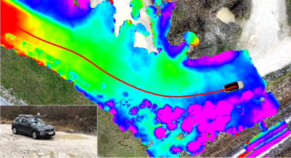
In their paper, the researchers present a real-time processing pipeline for environmental sensing in autonomous vehicles and robotics. In particular, the specific characteristics of radar sensors are taken into account. Although radar measurements are largely immune to external conditions such as rain or snow, they are significantly less accurate than lidar measurements. This measurement uncertainty is modeled when generating the 3D map of the environment and taken into account in an optimization process.
As you can see in the following video, these calculations are performed in real time:
We congratulate the three scientists, Philipp Glira, Christoph Weidinger, and Clemens Hofbauer, and their team on this significant success.
https://www.radar2023.org/best-conference-papers/


