Air Quality & Emission Management
Innovative APPlications for the augmented use of satellite observations to support Air Quality Management (APP4AQ) – Phase 2
THE CHALLENGE
In order to ensure clean ambient air, air quality authorities continuously monitor the levels of the relevant atmospheric components according to the 2008/50/EC directive/guideline. Measurement units are, however, expensive and their maintenance is labour-intensive. Thus, authorities can run only a very limited number of monitoring stations placed at selected locations to monitor the characteristic pollution stress , residential, industrial, traffic or hotspot sites. The air quality levels in between, or at other locations must be estimated using, e.g., trajectory analyses, air quality models and emission data. The integration of high-resolution satellite data and data products thereof might be the key to improve the area-wide air pollution spatial data coverage, as well as the temporal resolution, however, satellite data still play a minor role in atmospheric air quality monitoring due to difficulties in their accessibility and data characteristics not meeting all of the needs required for air quality monitoring purposes (e.g., temporal or spatial resolution) on its own.
THE PROJECT
APP4AQ exploits the coverage and information of recent and future satellite data from the European Union’s Copernicus programme for developing service-oriented applications for the field of air pollution control. Further data processing using measurements and modelling creates an added value and fosters satellite usage in the upcoming years.
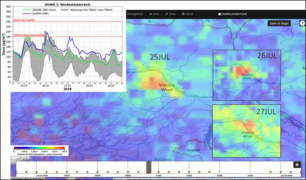
To provide easy access to the most recent and up-to-date satellite data across Europe and particularly Austria, a data management and visualization platform was developed, which does not only do that, but also brings together multiple layers of information on air quality. Only the combination of these layers provides experts with the necessary information to come to a full and clear understanding about the current air quality situation.
-
Processed satellite & model data – to better understand the extent and transport of air pollution, including cross-border, as well as large-scale emission events (e.g., Saharan dust, forest fires)
-
Emission inventory data - to better understand the origin of emissions and how to reduce them - see EMIKAT (<< Link to EMIKAT Website: https://cooperative-digital.solutions/de/emikat/ >>)
-
Air quality measurements – to better understand the exposure and impact - see UWEDAT (<< Link to UWEDAT Website: https://cooperative-digital.solutions/de/uwedat/ >>)
-
Air Quality forecasts – to better understand air quality situations to be expected in near future
Project Coordinator
ZAMG – Zentralanstalt für Meteorologie und Geodynamik
Project partners
AIT – Austrian Institute of Technology GmbH
TU Graz - Technical University Graz
SISTEMA GmbH
EODC – Earth Observation Data Centre
EOX IT Services GmbH


