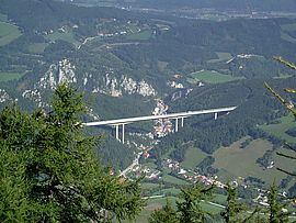
The aim of the SENBRIDGE research project is to investigate how to improve deformation measurements with a suitable sensor fusion and the use of Sentinel satellite data from ESA. Using the Schottwien bridge on the S6 as an example, this innovative method is to be developed and demonstrated in order to create the basis for a net-wide application. AIT's partner in this research project is ZAMG (Stabsstelle Erdbeobachtung, Bereich Daten, Methoden, Modelle).
In general, methods for non-contact condition monitoring of structures offer new possibilities for recording entire sections of infrastructure. Instead of equipping structures individually with discrete sensors, it is possible to use non-contact methods to record and evaluate difficult-to-access structures, entire sections of structures and their surroundings. If this is done with satellites from space, there is the added benefit of an extraterrestrial reference. Instead of collecting individual pieces of information at discrete locations, it will be possible in the future to use Synthetic Aperture Radar (SAR), a sensor for remote sensing using satellites, to monitor entire sections of roadway (e.g., a large number of bridges or settlement-sensitive structures) over a wide area. The decisive factor is whether the necessary accuracy for reliable statements can be achieved. The SAR method of Persistent Scatterer Interferometry (PSI) based on sentinel satellite data has the potential to continuously monitor the deformation behavior of many structures from a central location.
Compared to other data from radar satellites, the free Sentinel-1 radar data from ESA offer the advantage of greater temporal coverage (with two orbits six days apart), and thus better temporal resolution of the data.
In 2018 and 2019, a pilot study was implemented to test in principle the applicability of the methodology on the ASFINAG road network. The following core measures were suggested to improve the results:
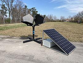
- Use of corner reflectors to control the deformation of discrete points, improvement of the mapping of points in individual satellite images,
- Optimization of data processing,
- Improvements in accounting for temperature deformation of the structure, both diurnal and seasonal,
- Sensor fusion - that is, combining different methods and sensors to reduce errors and increase resolution.

Test of the corner reflectors at the AIT site in Seibersdorf; these will later be installed on the Schottwien bridge; © AIT
In the meantime, significant progress has been made in optimizing the data processing since the completion of the feasibility study in 2019 due to the research activities of the project partners and the general further development of the methodology. Likewise, an improvement in the level of knowledge regarding the influence of a wide variety of factors within the deformation measurement has been achieved. There is already Europe-wide experience in the use of corner reflectors, also with regard to the design of such reflectors. These innovations are to be included in the present project.
Within the framework of SENBRIDGE, it will now be investigated how deformation measurements can be improved with a suitable sensor fusion and the use of sentinel satellite data.
Project duration: 06/2021 to 05/2023
AIT contact: Alois Vorwagner, Dominik Prammer, Philip Leopold
Contractor: ASFINAG Baumanagement GmbH
Project partners: ZAMG (Stabsstelle Erdbeobachtung, Bereich Daten, Methoden, Modelle)


