New concepts for more efficient, cost-effective, and sustainable drone service delivery and coordination.
Drones are already being used for numerous tasks in a wide range of applications. Examples include meteorological measurements, taking aerial photos and videos during torrent inspections, and surveying damage to buildings and infrastructure. Drones can also provide valuable data in the forestry, agricultural and municipal sectors, as well as after accidents, emergency and disaster events or for surveying.
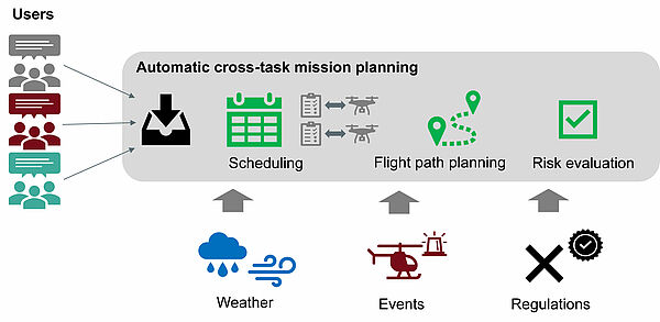
The project "Community Drone" develops and evaluates concepts and methods for a coordinated and collaborative use of drones by multiple user:s (e.g. municipalities, emergency services, infrastructure operators, energy providers, farmers & foresters, meteorological services, etc.). Automated and cross-task mission planning enables efficient drone use for multiple tasks by optimizing drone utilization and synergies between missions (simultaneous execution of multiple tasks). In doing so, the timing of execution is coordinated according to priority and external conditions (weather forecasts, rescue missions, ...). Taking into account the legal and regulatory framework (flight bans, permits), a safe and efficient flight route and flight time is also selected for each task, and the equipment used (drone, sensors) is matched to the specific mission area and terrain.
The objectives of the project are to demonstrate the functionality of cross-task mission planning for community drones in simulation, to evaluate the increase in efficiency and the economic potential, and to analyze the technical, organizational, and legal feasibility, as well as the framework conditions required for practical operation.
Funding: The community drone project is funded by the Federal Ministry for Climate Protection, Environment, Energy, Mobility, Innovation and Technology (represented by Österreichische Forschungsförderungsgesellschaft mbH) within the TAKEOFF 2021 call.


