
Greater safety and quality in cycling through better data
Cycling is a key component of the mobility transition: it helps reduce emissions, improves public health, and enhances the quality of life in cities and communities. However, to make cycling safe and attractive for all age groups—from children to seniors—high-quality infrastructure is needed.
This infrastructure must be sufficiently wide, continuous, well maintained, and intuitive to use.
However, the current data on the condition and design of cycle paths in Austria is inadequate. Different standards exist in the federal states, with varying levels of detail and quality in the surveys. However, public authorities need reliable, comprehensive information that is consolidated in the Graph Integration Platform (GIP), the official digital transport network. This is the only way to systematically remedy deficiencies, close gaps, and maintain infrastructure in the long term.
The InfraRad project: Efficient, objective, and comparable data collection
The new InfraRad research project, led by the AIT Austrian Institute of Technology, aims to develop a harmonized method for surveying and evaluating cycling infrastructure throughout Austria. The goal is to collect data efficiently and objectively, document the condition of bike paths transparently, and provide a solid foundation for planning and maintenance processes.
The focus is on a standardized survey catalog developed in collaboration with representatives from administration, infrastructure planning, and research. It defines the characteristics that a safe and forgiving cycling infrastructure must fulfill—and the methodology that can be used to reliably collect these characteristics.

Karin Markvica, project manager at AIT, describes the approach as follows: "The cornerstones of the ‘InfraRad’ project are a standardized survey catalog for bicycle infrastructure, which is developed together with stakeholders, the testing of possible survey methods using a measuring bicycle, and the resulting findings on the level of detail of the data and the integration of the new data into the GIP. Our goal is to ensure that infrastructure operators and planners in Austria are provided with exactly the data they actually need in their everyday work in the long term."
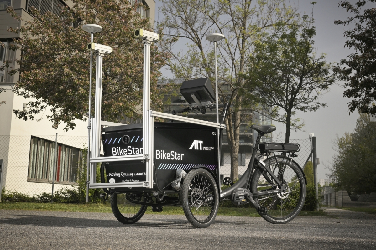
BikeStar: Precise measurement using a measuring bike
A key tool in the project is the AIT measuring bike BikeStar. This is a three-wheeled transport bike that functions as a mobile measuring laboratory with state-of-the-art sensor technology. The BikeStar is equipped with 3D cameras, LiDAR laser scanners, precise coupling navigation, inertial sensors, and temperature sensors. This allows properties such as road width, surface condition, gradients, visibility, traffic signs, and even thermal stress to be objectively recorded—even on narrow or difficult-to-access sections.
The data is automatically evaluated, for example to detect road damage or analyze driving comfort. This not only enables a comprehensive inventory to be taken, but also allows ongoing infrastructure monitoring, which facilitates targeted maintenance measures. The BikeStar is being further developed in accordance with the requirements of stakeholders in Austria in the InfraRad project in order to be able to collect all the necessary parameters.
Nationwide benchmarking as a goal
InfraRad aims not only to improve the condition of cycling infrastructure locally, but also to make it comparable across regions. Nationwide benchmarking will help decision-makers at federal, state, and local levels prioritize investments. At the same time, integration into the GIP will ensure that all relevant data is centrally available and can be used sustainably.
Project partners: ITS Vienna Region / Verkehrsverbund Ost-Region (VOR) GmbH
Funding body: Austrian Road Safety Fund (VSF) of the Federal Ministry for Innovation, Mobility, and Infrastructure (BMIMI) as part of the 7th call for proposals on the topic of „fahr – Rad – sicher!“